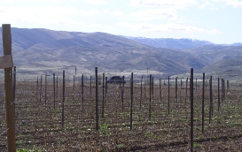
The old Ellis Place, site of Two Joseph's Vineyard, is 73 acres of high quality farmland on the floor of Eagle Valley. The property is relatively flat and has little intrinsic protection against frost. In contrast, the southern portion of the property overlooks Brownlee Reservoir from a height of about 100 feet, where ~20 acres of sloped land face directly south in sight of the reservoir. We expect this location to offer significant frost protection. The current test vineyard is located on flat ground in north of the property, which we thought offered little protection against radiation frosts. However, sensons last spring showed the current site to be ~1.5-2° F warmer during a frost than other sites on the property.
The vineyard's soils are comprised of brown, well drained, slightly acidic silt loam that contains almost no stone and little organic material. The soil is about 3' deep and overlays a thick duripan that is comprised of cobbles and gravel that were cemented together over many hundreds of thousands of years. Below the duripan lies a deep alluvial deposit that is made up of cobbles and gravel. Below this are sedementary lake deposits.
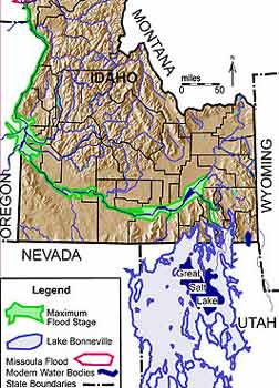
We believe our topsoil was deposited by the Bonneville Flood, a catastrophic geological event that occurred about 14,500 years ago. This flood was larger in volume than the more famous Missoula Floods, and took a much longer period of time to subside. The flood occurred when the Bear River in southeastern Idaho breached the shores of Pleistocene Lake Bonneville at Red Rock Pass. The enormous fresh water lake (the size of today's Lake Michigan) released a torrent of water into the Snake River basin. At its peak, the flood may have been 410 feet deep at the site of today's Brownlee Dam in Hells Canyon, and would have covered Eagle Valley with 100 or more feet of water. The great Bonneville Flood may have taken as long as a year to subside, leaving in its wake the silt that is today's vineyard topsoil.
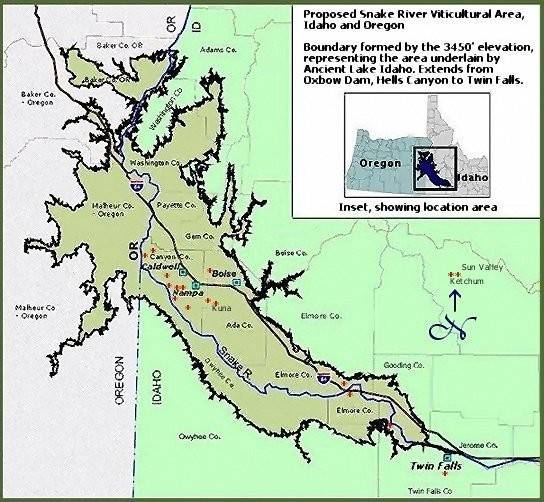
The vineyard's underlying cobbles and gravel were presumably deposited by the Powder River and Eagle Creek, which brought materials from the neighboring Wallowa/Eagle Cap Mountains, a spur of the Blue Mountains. Below these alluvial deposits are sediments from ancient Lake Idaho, including, we assume, the "chalk" deposits that are visible at Brownlee Reservoir. This massive Pliocene lake system covered much of today's western Snake River plain in southern Idaho, reaching a maximum elevation of 3600 ft approximately 4 million years ago. At that time, all of Eagle Valley would have been under water. Lake Idaho was drained by the ancestral Hells Canyon approximately 2-3 million years ago, leaving Eagle Valley dry. The Powder River and Eagle Creek then cut down through the lake sediments, leaving the fertile benchland that comprises much of the valley's agricultural land today. The boundaries of the Snake River Valley AVA (American Viticultural Area), which Two Josephs Vineyard falls within, are defined by the ancient expanse of Lake Idaho.